
Download to ZOOM IN/OUT ~ Ancient Indian (Bharata) Cities and Places (English)

2017 Political Map of India by Survey of India.jpg
http://pahar.in/?wpfb_dl=16503
US Army Map Service 1:250,000 scale mapping of Northern India and Pakistan, dating from the 1950s and 60s
https://maps.lib.utexas.edu/maps/ams/india/
1969 The Kingdom of Sikkim by Pradyumna P. Karan
Pradyumna Prasad Karan (1930 – 2018) was also to many as known as Paul. He was one of the most influential South Asian geographers in the United States. Professor Karan made important and significant contributions to Geography broadly and Asian Studies specifically through more than 300 publications (including 16 books and numerous articles). A major focus of Karan’s early research (1956-70) was on the Himalayan landscape including Nepal, Bhutan, Sikkim and Tibet, to which he would devote the bulk of his scholarly career. Through his research he would provide pioneering geographic survey data and findings based on archival and field research of these mountainous regions of the world. In recognition of his deep commitment to and knowledge of the Himalayan region, he was awarded the Sir George Everest Gold Medal for cartographic, environmental, and resource mapping in the Himalaya (1982).
http://pahar.in/?wpfb_dl=16651
https://nla.gov.au/nla.obj-2762975177/view
2004 Tourist Map of Ladakh and Zangskar by Hanish and Co
http://pahar.in/?wpfb_dl=24823
Adyar
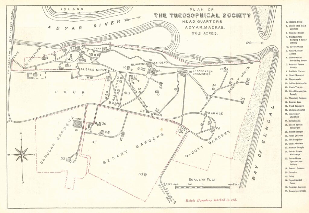
1 Vasanta Press 2 Site of Star Headquarters 3 Arundale House 4 Headquarters Building & Adyar Library Record Office 4a Record Office 5 Adyar Library Annex 6 Theosophical Publishing House 7 Vasanta Puram Houses 8 Buddhist Shrine 9 Olcott Memorial 10 Bhojanasala 11 Indian Ouadrangle 12 Hindu Temple 13 Site of Zoroastrian Temple 14 Blavatsky Gardens 15 Banyan Tree 16 Wood Bungalow 17 Christian Church 18 Leadbeater Chambers 19 Sevashrama 20 Site of Jewish Synagogue 21 Muslim Mosque 22 Parsi Quarters 23 Bell Bungalow 24 Olcott Gardens 25 Masonic Temple 26 Power House Workshops 27 Power House Dynamos and Battery 28 Besant Gardens 29 Laundry 30 Dairy 31 Experimental Farm 32 Damodar Gardens 33 Cremation Ground
Amritanandamayi ashrams
Amritapuri, originally Parayakadavu, is the main ashram of Sri Mata Amritanandamayi Devi. Amritapuri is also the International Headquarters of Mata Amritanandamayi Math. Located in Kerala, about 120 km south of Kochi.
Ahmedabad Amritapuri Ashram Andaman Islands Bengaluru Coimbatore Chennai Davengere Ernakulam Hyderabad Kolkata Kodungallur Kozhikode Madurai Mananthavady Mangalore Mumbai Mysore New Delhi Palakkad Pune Tiruvananthapuram Talassery Trissur
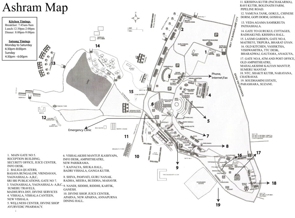
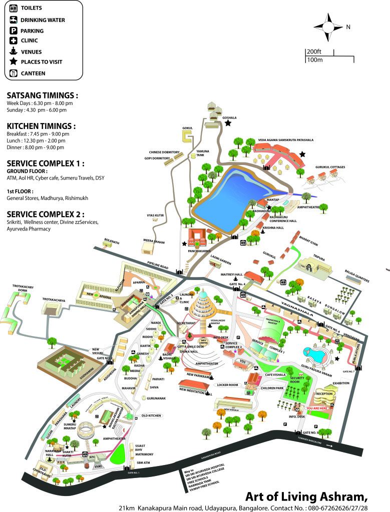
Art of Living Ashram Map
Ashrams of India: Volume 1, Chapter 10 Karnataka.
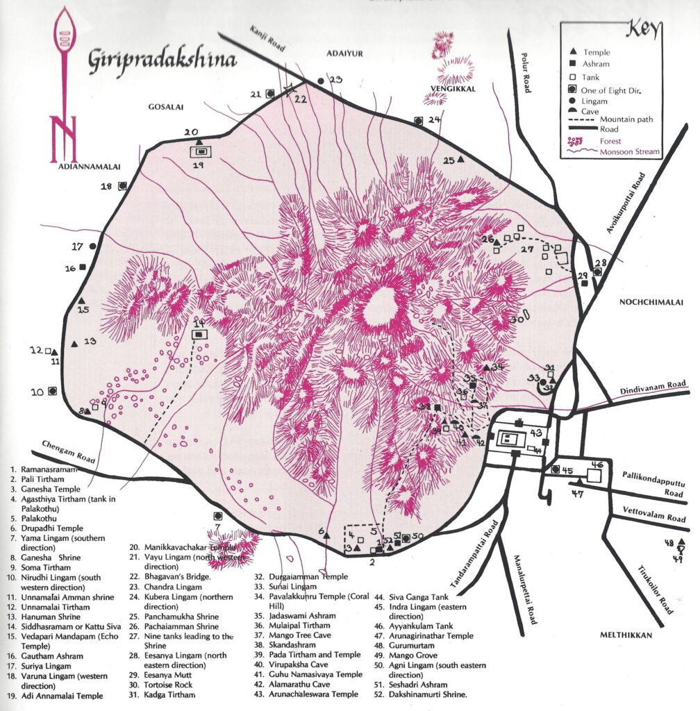
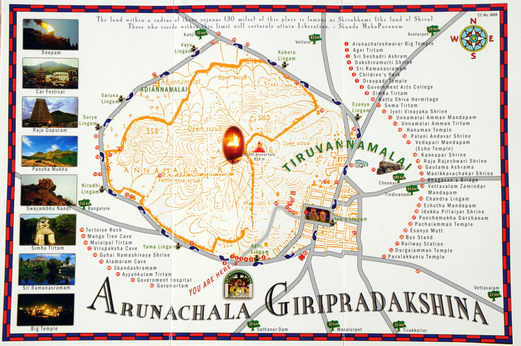
Arunachala Giripradakshina
Ashrams of India: Volume 2, Chapter 19 Tamil Nadu.
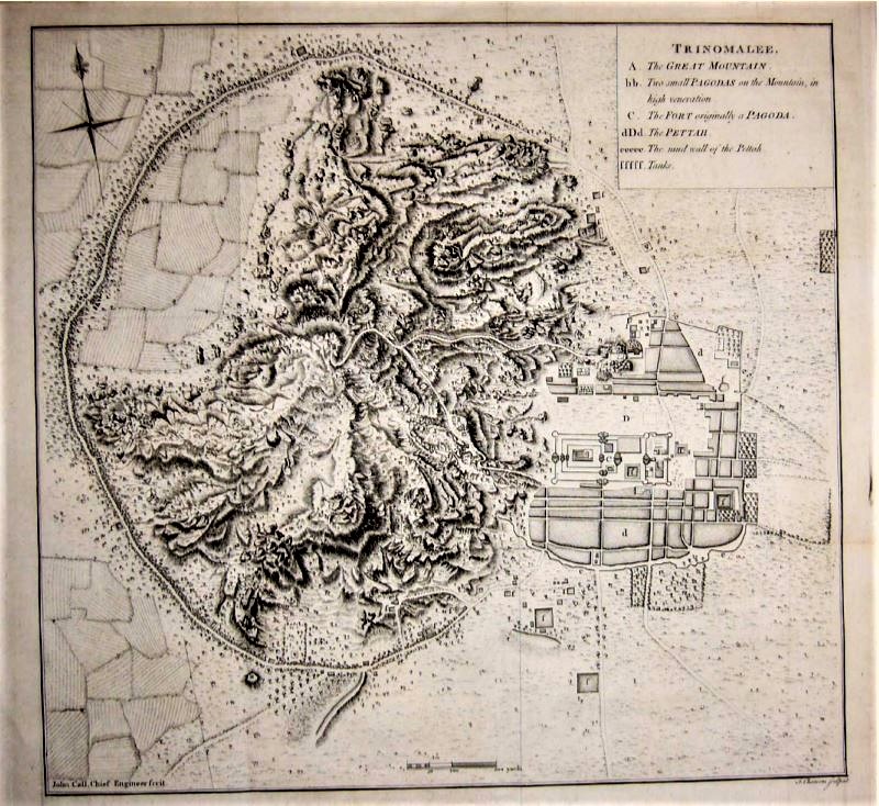
Close inspection of the map reveals the letter ‘b’ at the top of the mountain which, according to Cheever’s key, means there was a shrine on the summit at that time. We can speculate that this may have been a Murugan Shrine but no details about the shrine (referred to as ‘Pagoda’) are provided. Uncharacteristic of British cartographers of the time, Cheever seems to accept that Arunachala is no ordinary geological uplift and designates it as ‘The Great Mountain.’
Drawn manually, Cheever’s map is strikingly similar to modern satellite images. It may be assumed that Cheever did his directional survey and basic topography from the Hill’s summit. A curious omission is the ashtalingas. Since Cheever was a stickler for detail (as royal cartographers tended to be), we can assume that the ashtalingas were not housed in mantapams in 1755. Also not depicted, the mantapam to Mother in the Big Temple, which was erected later. It should be stated royal maps of the time were not commissioned out of cultural interest, but military interest, and this item would have been viewed as having strategic value during the colonial period. From Saranagati Magazine October 2021.
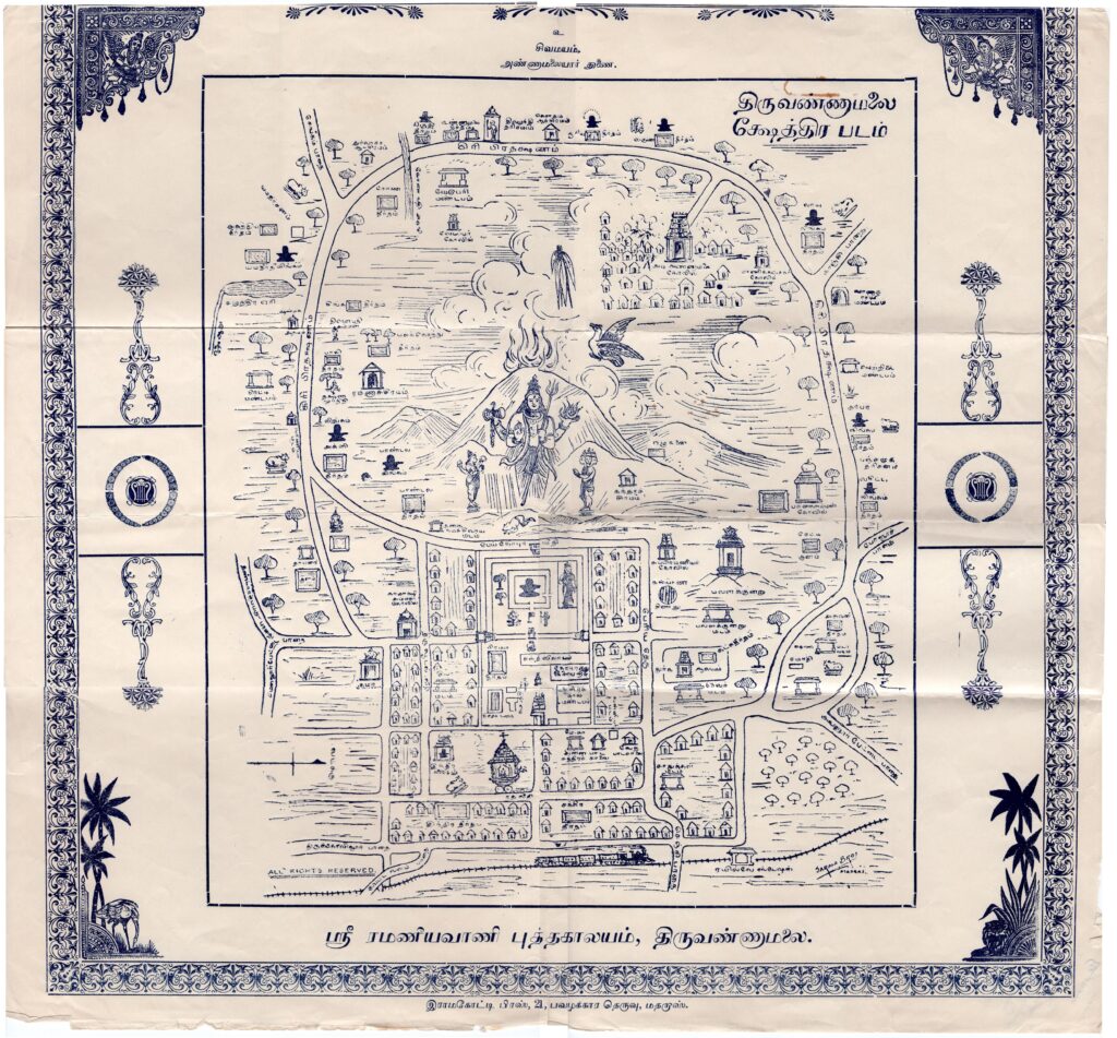
“The Sacred Hill & Beacon of Tiruvannamalai,” and “Quaint map of Hill of Holy Beacon, showing Arun & Road & wayside Shrines & Temples – Drawn by Eeswara Swami”
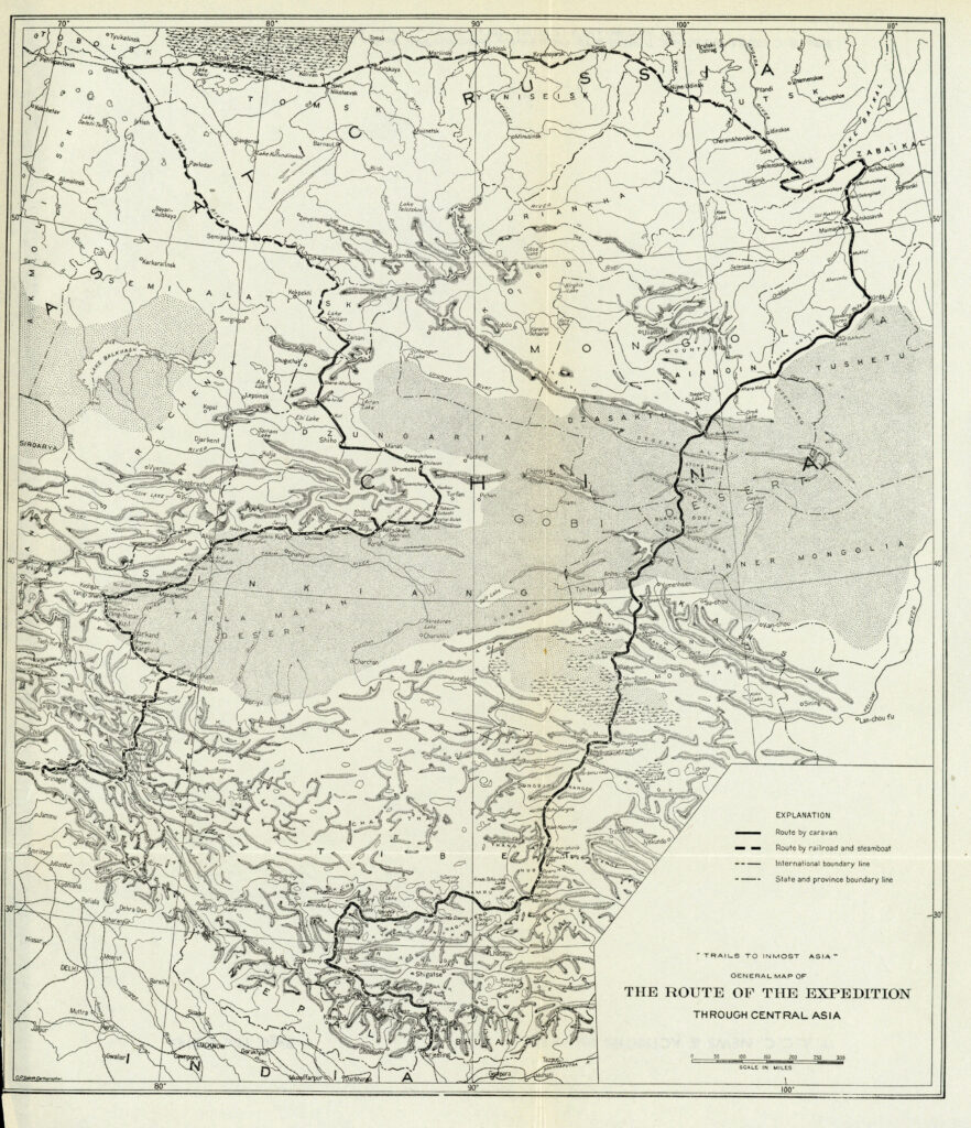
Attempt on Lhasa
Susanna “Susie” Carson Rijnhart, (later Moyes, 1868-1908) was a Canadian medical doctor, Protestant missionary, and Tibetan explorer. She was the second Western woman known to have visited Tibet, after Annie Royle Taylor.
Rijnhart lived and traveled among the Tibetans from 1895-1899. Her child died and her husband Peter disappeared during this period. A member of the Foreign Christian Missionary Society, she later remarried.
The Rijnharts, baby Charles, and three local hired men, two Chinese and one Muslim, left Tankar on horseback, May 20, 1898. Their destination was Lhasa, eight hundred miles away as the crow flies but across a series of mountain ranges through passes at elevations of up to 5,000 metres (16,000 ft). They carried with them food and other supplies sufficient for two years as well as several hundred bibles translated into Tibetan. Following a known caravan route to Lhasa, they skirted the Tsaidam and proceeded southwest, roughly following the track a modern highway follows today.
All went well for more than two months until their two Chinese hired men deserted. Shortly thereafter, on August 11, five of their pack animals were stolen. On August 21, the baby Charles died suddenly. They were at this time just north of the district capital of Nagchu, 14,850 feet (4,530 m) in elevation. As they continued Tibetan soldiers tried to persuade them to abandon their quest and return the way they had come. A Tibetan official in Nagchu refused to allow them to continue to Lhasa, only 100 miles further south, or to remain in Nagchu, but insisted they leave Tibet via a caravan route leading to Kangding (Tachienlu), 600 miles to the east. Their reliable Muslim guide departed at this time, with their permission, to journey to his home in Ladakh and they were left alone at the mercy of the Tibetans.
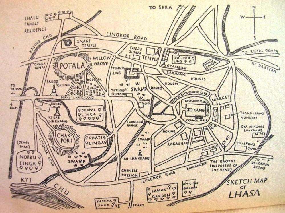
Sketch Map of Lhasa by Tuesday Lobsang Rampa
Sri Aurobindo Ashram Section of Pondicherry Map
Ashrams of India: Volume 2, Chapter 25 Puducherry.
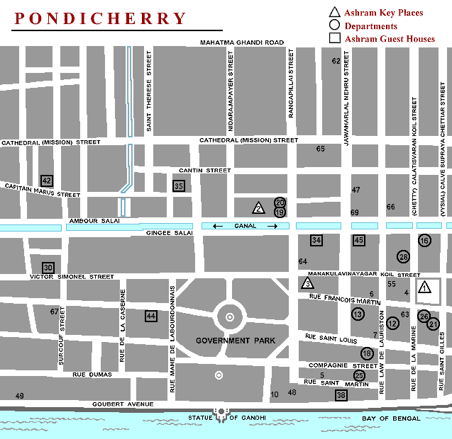
| Ashram Key Places (triangles) #1 Ashram Main Building #2 Bureau Central #3 Dining Room #28 SABDA – Kripa BranchAshram Guest Houses (squares) #2 Cottage Guest House #30 Oriya Nilayam #34 International Guest House #35 Navajyoti Press House #38 Sea Side Guest House #42 Karnataka Nilayam #44 Samarpan #45 Society House | Departments (circles) #12 Art Gallery #13 Art House #16 Auroshikha Agarbathies #18 Batik Section #19 Cottage Industries #20 Cottage Restaurant #21 Fleurs en Flacon #25 Marbling Group #26 Mother’s Embroidery Dept. |
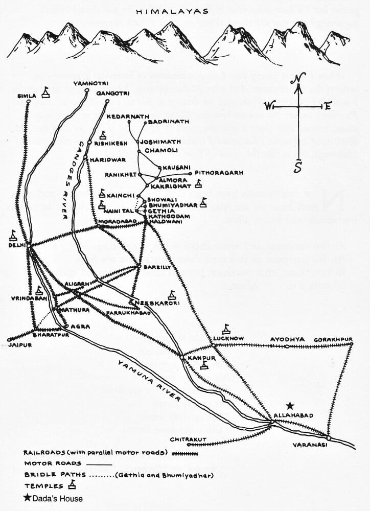
Ashrams of Neem Karoli Baba
Ashrams of India: Volume 1 and Volume 2.
The map shows: Shimla Temple, Delhi Ashram, Vrindavan Ashram, Rishikesh Ashram, Kainchi Ashram, Kakrighat Temple, Bhumiadhar Temple, Nibkarori Temple, Lucknow Hanuman Sethu Ashram, Kanpur Panki Temple.
Neem Karoli Baba (Maharajji) wandered throughout India to thousands of places. This map shows but a few of those places (the map is from Miracle of Love by Ram Dass, page 404).
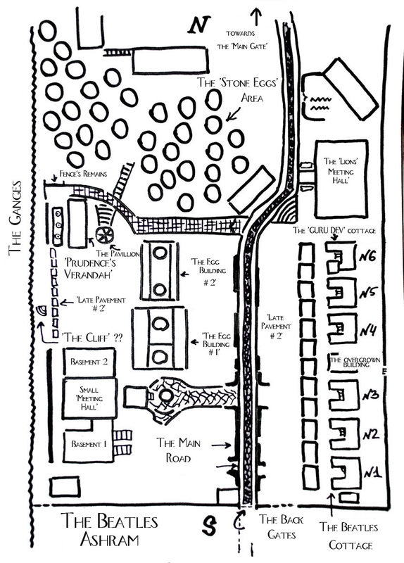
Beatles Ashram Map
Ashrams of India: Volume 2, Chapter 21 Uttarakhand.
Ashram map drawn by Anna.
http://annaintheworld.weebly.com/rishikesh-india-in-english
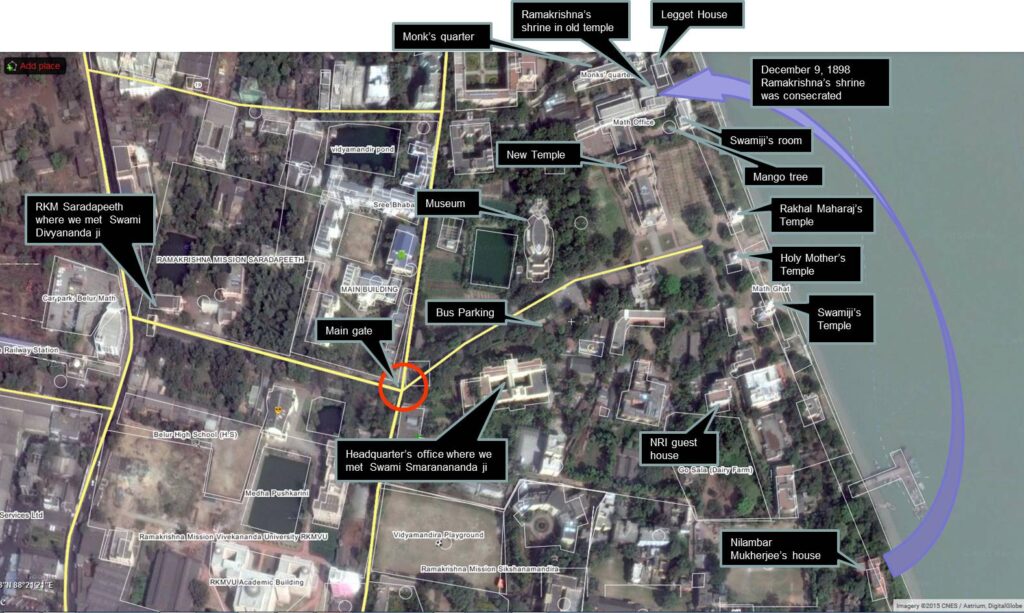
Belur Math
Ramakrishna Math, Kolkatta. Ashrams of India: Volume 2, Chapter 23.
Click on the link below to the maps for all the Ramakrishna Maths and the Ramakrishna Missions (221 branch centres worldwide, with 167 in India).
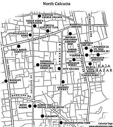
Calcutta Yoga
Ashrams of India: Volume 2, Chapter 23 West Bengal.
Recommended Books: Calcutta Yoga: Jerome Armstrong.
Cave of Alexandra David-Neel/Deothang Cave and the Cave of Lachen Gomchen/Deothang Cave
Ashrams of India: Volume 1, Chapter 18 Sikkim.
Based in this cave for 2 ½ years, Alexandra David-Neel went on to become the second Western woman to visit Tibet, and the first Western woman to visit Lhasa and to speak to the Dalai Lama.
Lachen Gomchen Rinpochi stayed in this upper cave and meditated for 13 years, it was later used by the 3rd Lachen Gomchen Rinpoche, Alexandra David-Neel’s master.
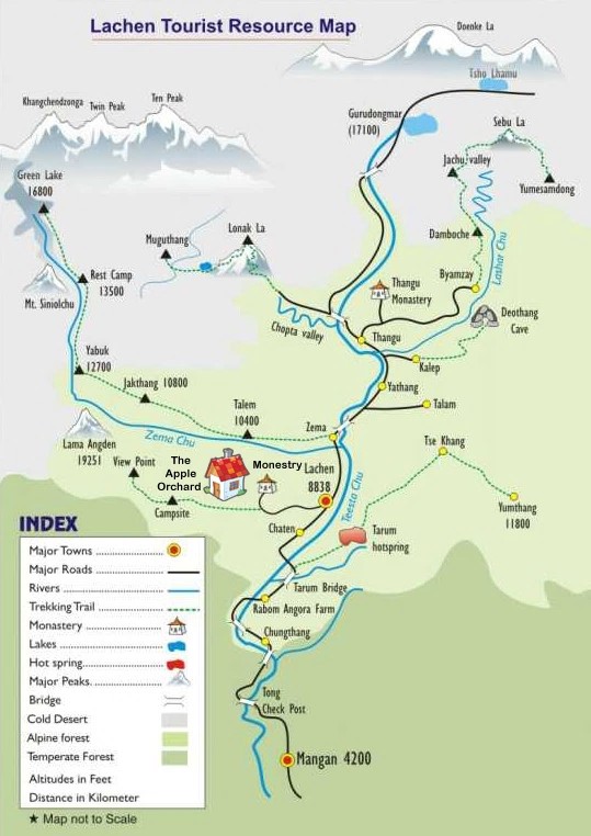
The Four Sacred Caves of Sikkim
Ashrams of India: Volume 1, Chapter 18 Sikkim. The four sacred caves of Sikkim were discovered by the 8th century Tibetan saint, Guru Rinpoche who used them for meditation and for the storage of scriptures and wealth after subduing the local spirits and so making the caves places of sacred refuge and offering. Rinpoche arrived in India from Tibet after being instructed by the king to find a safe place for pilgrimage and worship for the Buddhist practitioners of Tibet after acknowledging the likelihood of his sovereignty being overthrown. The caves then became the traditional abodes of Guru Rimpoche and Lhatsun Chempo, who was largely responsible for consolidating Buddhism in Sikkim.
The Secret Cave of the Dakinis Cave associated with the ‘God of Increasing Knowledge’ and where all wishes for longevity, virtues and abundance will be fulfilled.
The Hidden Cave in the East Believed to be the first cave to be blessed by Guru Padmasambhava and still alive with mystical energies and power.
The Cave of Great Bliss
One can acquire ‘Supreme Higher Attainment’ just by going to this cave.
Cave of God’s Precious Heart
A pilgrimage to this cave brings about favourable signs of growth as well as spiritual realisation.
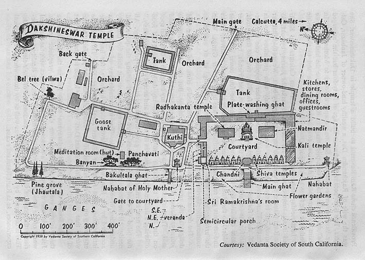
Dakshineswar Temple
Ashrams of India: Voume 2, Chapter 23.
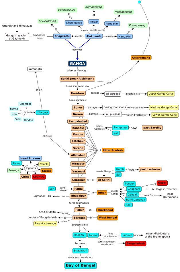
Ganga – Watching The River Flow
Jeeva Samadhi
https://www.sidhdhars.com/jeeva-samadhis-map/
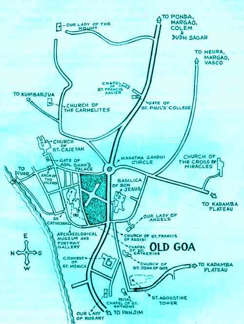
Old Goa
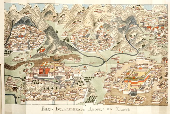
Old Map of Lhasa
LAMRIM Mind Map
(By Tsem Rinpoche)
Two of my friends, Lili Ng and Thierry Janssens came out with a creative idea to summarise the Lamrim – in mind map form and offered it up to me in April 2010. This mind map is a overview of one of Buddhism’s holiest texts, and the book upon which we base our lineage.
They used Liberation in the Palm of Your Hand: A Concise Discourse on the Path to Enlightenment by Pabongka Rinpoche as the source text and summarised the whole Lamrim with the corresponding parts, major headings, main gists, page numbers, and there were even drawings of the wheel of life on the lower right corner of the mind map.
Thierry did a great job with the mind map module and Lili did the drawing/layout/handwriting of the mind map. It was beautifully framed and currently I had it displayed in Kechara House 2. Thierry and Lili are such a fantastic creative team!!!!! I am so amazed with this mind map. I love it. I love it.
Both Lili and Thierry attended the Lamrim classes held weekly at Kechara House which Liaison Ngeow taught.
Lili is also a regular volunteer at Kechara Saraswati Arts, where she has recently been working on the restoration of my personal statue of my root guru His Holiness Kyabje Zong Rinpoche. Lili is very talented. Extremely talented.
tsemrinpoche.com
Ma Anandamayi ashrams
Ashrams of India: Volume 1 and Volume 2.
AGARPARA Shree Shree Ma Anandamayi Ashram, P.O. Kamarhati, Kolkata 700 058 (Tel 033 2553 1208)
Link to more about Agarpara Ashram
AGARTALA Shree Shree Ma Anandamayi Ashram,. Palace Compound P.O. Agartala 799 001 West Tripura (Tel 0381 2208618, mb 9436122507, Link to Agartala Ashram details)
ALMORA Shree Shree Ma Anandamayi Ashram, Patal Devi, P.O. Almora 263 602 (Tel 05962 233120, mb 8141 509809)
Link to more about Almora Ashram
ALMORA Shree Shree Ma Anandamayi Ashram, P.O. Dhaul-China, Almora 263 881 (Tel 05962 262013)
Link to more about Dhaulchina Ashram.
Link to details of Richard Lannoy’s painting kept at the ashram
BHIMPURA Shree Shree Ma Anandamayi Ashram,, Bhimpura, P.O. Chandod, Baroda 391 105 (mb 942 7474040, Sw mb 8141 509809)
Bhimpura is near Chandod, not to be confused with another Bhimpura near Baroda.
Link to more about Bhimpura Ashram
BHOPAL Shree Shree Ma Anandamayi Ashram,, P.O. Bairagarh, Bhopal 462 030 M.P. (Tel 0755 2641227, 269227)
Link to more about Bhopal Ashram/School
DEHRADUN Shree Shree Ma Anandamayi Ashram, Kishenpur, P.O. Rajpur, Dehradun 248 009 (Tel 0135 2734 271, mb 9758 218555)
DEHRADUN Shree Shree Ma Anandamayi Ashram, Kalyanvan, 176 Rajpur Road, P.O. Rajpur, Dehradun 248 009 (Tel 0135 2734471, mb 9758 218555) Link to more about Kalyanvan Ashram
DEHRADUN Shree Shree Ma Anandamayi Ashram,P.O. Raipur Ordnance Factory, Dehradun 248 010 (Tel mb 9758 218555)
DEHRADUN Shree Shree Ma Anandamayi Ashram, 47/A Jakhan, P.O. Rajpur, Dehradun (Tel mb 9758 218555)
JAMSHEDPUR Shree Shree Ma Anandamayi Ashram, Near Bhatia Park, Kadma, Jamshedpur 831 005, Bihar (Tel 0657 2306245, mb 9631 082115)
KANKHAL Shree Shree Ma Anandamayi Ashram, P.O. Kankhal, Hardwar 249 408 (Tel mb +91 955 7009159 10 am – 1 pm and 4pm – 6pm) email: anandmayeesangha@rediffmail.com) Link to more about Kankhal Ashram.
Link to Ashram Booklet.
KEDARNATH Shree Shree Ma Anandamayi Ashram, Near Himlok, P.O. Kedarnath, Rudraprayag, 246 445 (Mob 8979834548)
NAIMISHARANYA Shree Shree Ma Anandamayi Ashram, Puran Mandir, P.O. Naimisharanya, Sitapur 261 402 U.P. (Tel 05865 251369, mb 8171 055225, Puranic Inst 05865 251249)
NEW DELHI Shree Shree Ma Anandamayi Ashram, Kalkaji, New Delhi 110 019 (Tel 011 2682 6813, mb 9661 896283)
PUNE Shree Shree Ma Anandamayi Ashram, Ganesh Khind Road, Pune 411 007 (Tel 020 2552 8835, mob 9273 346691)
Link to more about Pune Ashram
PURI Shree Shree Ma Anandamayi Ashram, Swargadwar, Puri 752 001, Orissa (Tel 06752 223258, mb 9831 0008448)
Link to more about Puri Ashram
RAJGIR Shree Shree Ma Anandamayi Ashram, P.O. Rajgir, Nalanda 803 116 Bihar (Tel 06112 647 590, mob 9359 215567)
RANCHI Shree Shree Ma Anandamayi Ashram, Main Road, P.O. Ranchi, 834 001, Bihar (Tel 0651 233 1181)
TARAPEETH Shree Shree Ma Anandamayi Ashram, P.O. Chandipur-Tarapeeth, Birbhum 731 233 W.B. (Tel 0943 4008381)
UTTARKASHI Shree Shree Ma Anandamayi Ashram, Kali Mandir, P.O. Uttarkashi, 249 193, UA (Tel 01374 224343, mb 8791 476603)
Link to more about Uttarkashi Ashram
VARANASI Shree Shree Ma Anandamayi Ashram, Bhadaini, Varanasi 221 001 (Tel 0542 2310054/2311794, mb 9451 973749, Hospital 2310230, email: maa.varanasi@gmail.com)
Link to more about Varanasi Ashram
VINDHYACHAL Shree Shree Ma Anandamayi Ashram, Ashtabhuja Hill (nr Gov. Guesthouse), P.O. Vindhyachal, Dist Mirzapur 231 307, UP (Tel mb 7007 930641, 094508 56422, 09793 967616, 09648 998940). Best after 8pm.
Link to more about Vindhyachal Ashram
VRINDAVAN Shree Shree Ma Anandamayi Ashram, P.O. Vrindavan, Mathura, 281 121 U.P. (Tel Mb 9219415554, 9456418375)
Link to more about Vrindavan Ashram
BANGLADESH
DHAKA
Shree Shree Ma Anandamayi Ashram, 14 Siddheshwari Lane, P.O. Ramna, Dhaka 17, Bangladesh. (Tel 0088 01712 643147, 8333917 Ratan)
Link to more about Ramna Ashram
KHEORA
Shree Shree Ma Anandamayi Ashram, P.O. Kheora, via Kasba, Brahmanbaria 554, Dist Khandawa, Bangladesh.
(Tel 0088 1711 619798, mb 91 9674 988186)
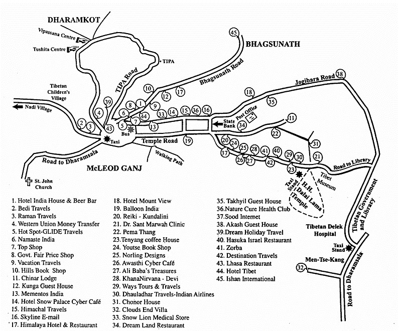
McLeod Ganj
Ashrams of India: Volume 1, Chapter 7 Himachal Pradesh.
Milarepa’s Cave
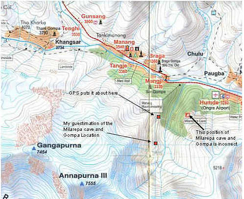
Milarepa’s Cave at 4000m 3 – 3.5 hours hike marked by blue/white markers.
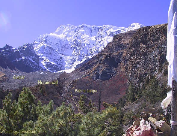
Milarepa is said to have stayed in this cave for meditation. This little cave is below Annapurna III and a small little Gompa was later built near the cave. It is a very pleasant walk through a forest into a side valley below Annapurna III with good views of Pisang peak.
How to get there: Go east (Direction to Mungji/Pisang) for about 300-500 m and cross the river on the bridge. After the bridge turn right (west) for about 50 m until you reach a small trail with blue/white marks leading to the hillside. Follow it to the left (south) until you reach the forest and climb up the trail (the owner of Braka Bakery has marked out this trail with the blue/white markers). You will reach a place with a nice Stupa and many prayer flags. Continuing on you will get out of the forest and climb up the valley until you reach the little Gompa. Milarepa’s cave is about 15 minutes further up. The cave has a small entrance and is protected by some little stonewalls.
The problem with all this is where in the valley is the actual location. I am tempted to place it further up the valley but I don’t remember crossing any side streams and none are visible in my photos so I have to assume the Gompa is located before the streams on the map. The map doesn’t show the huge glacier in the valley either! We do know the Gompa is at just over 4,000m elevation and the Nepal map also had it on the 4,000m elevation line. As best I remember we climbed for about a kilometer or more after we turned up the main valley to the Gompa. Other reports in LP etc have the Gompa at 4,000m and the caves at 4,300m but the caves pointed out to us as Milarepa’s and the one holding the bow were only 100m or so above the gompa. The Gompa is quite simple but elegant and surrounded by many other buildings to house pilgrims which flock there at various times of the year. Each town seems to have a different time during which they celebrate for several days at the site.
Annapurna Circuit: click on the link below for information and pictures of the trail to Milarepa’s Cave.
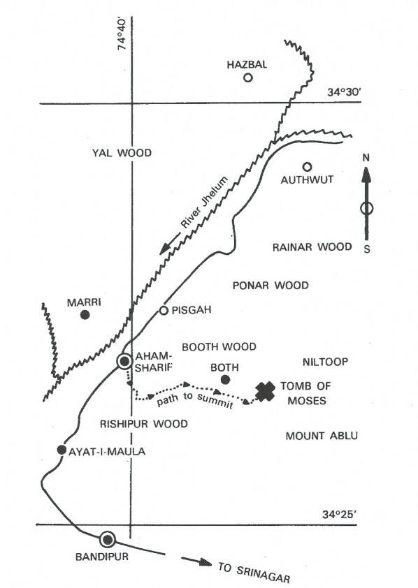
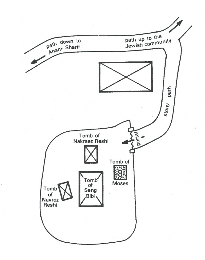
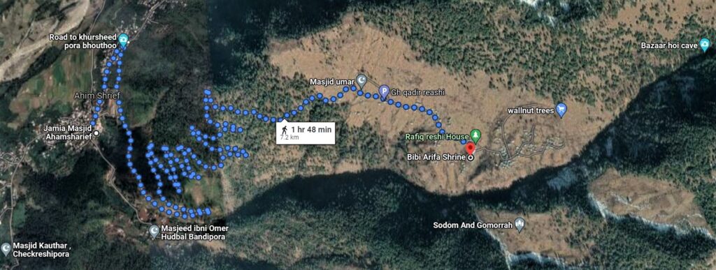
Grave of Moses in Kashmir
Ashrams of India: Volume 1, Chapter 8 Jammu & Kashmir.
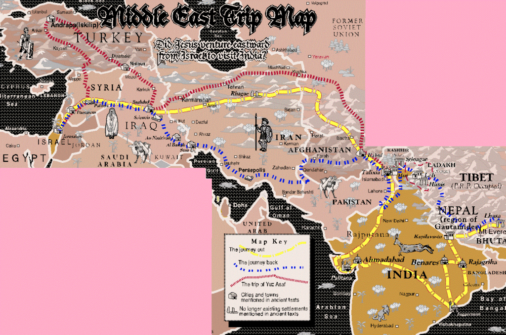
Travels of Jesus to the British Isles
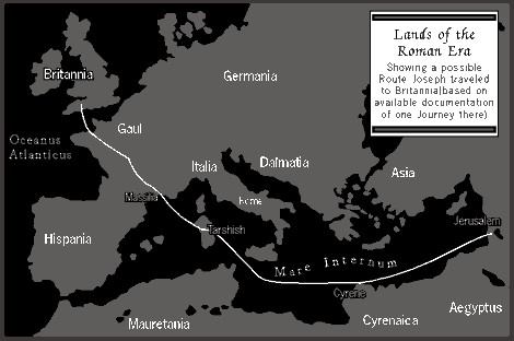

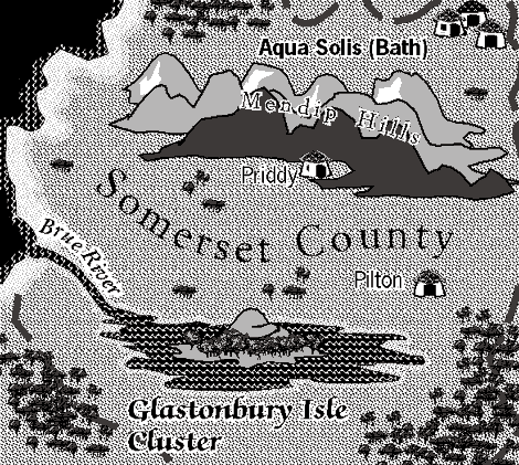
Travels of Jesus to and from India
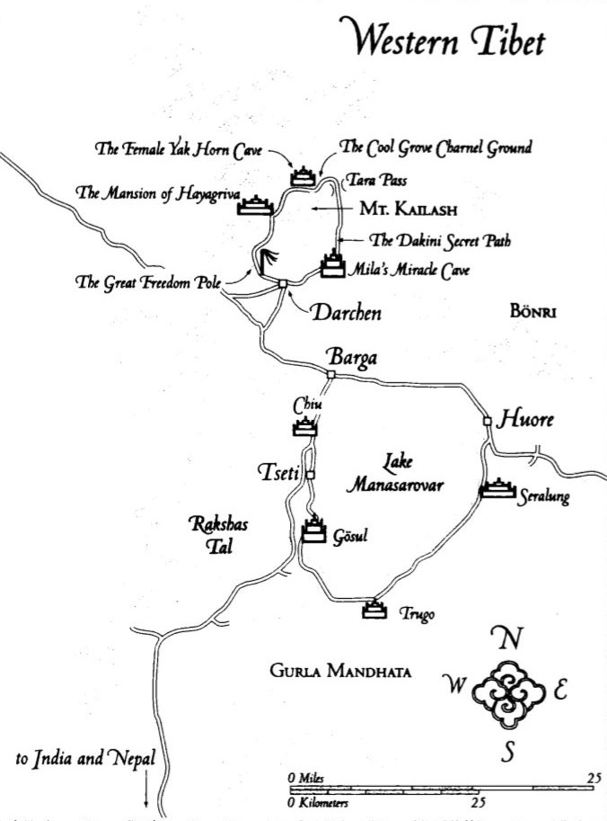
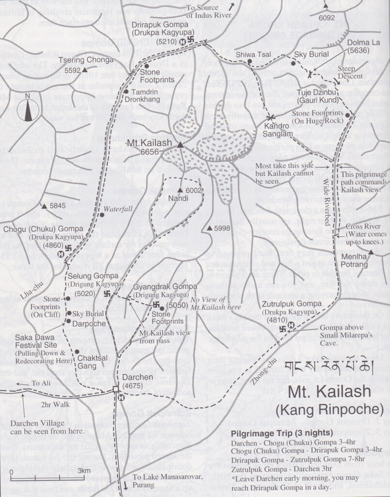
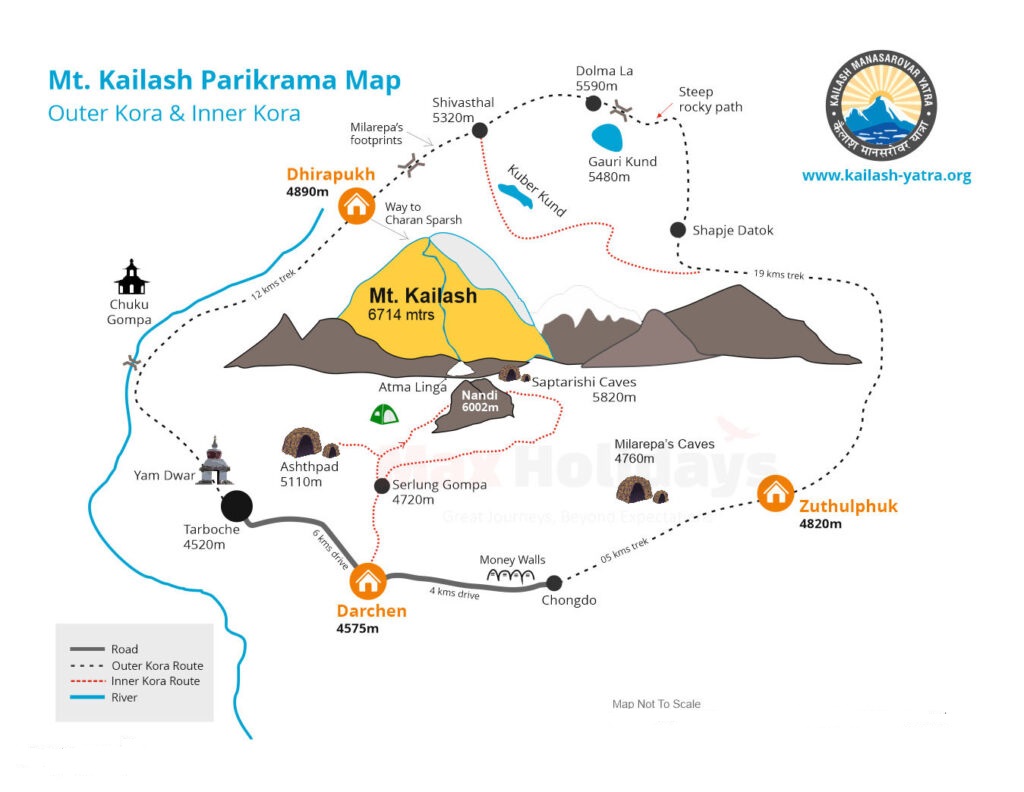
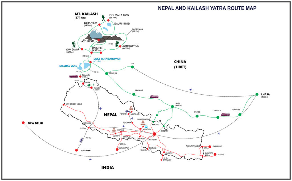
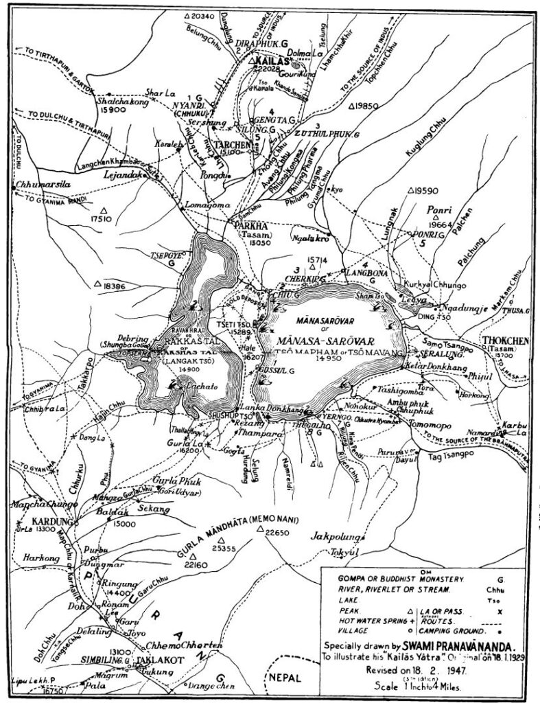
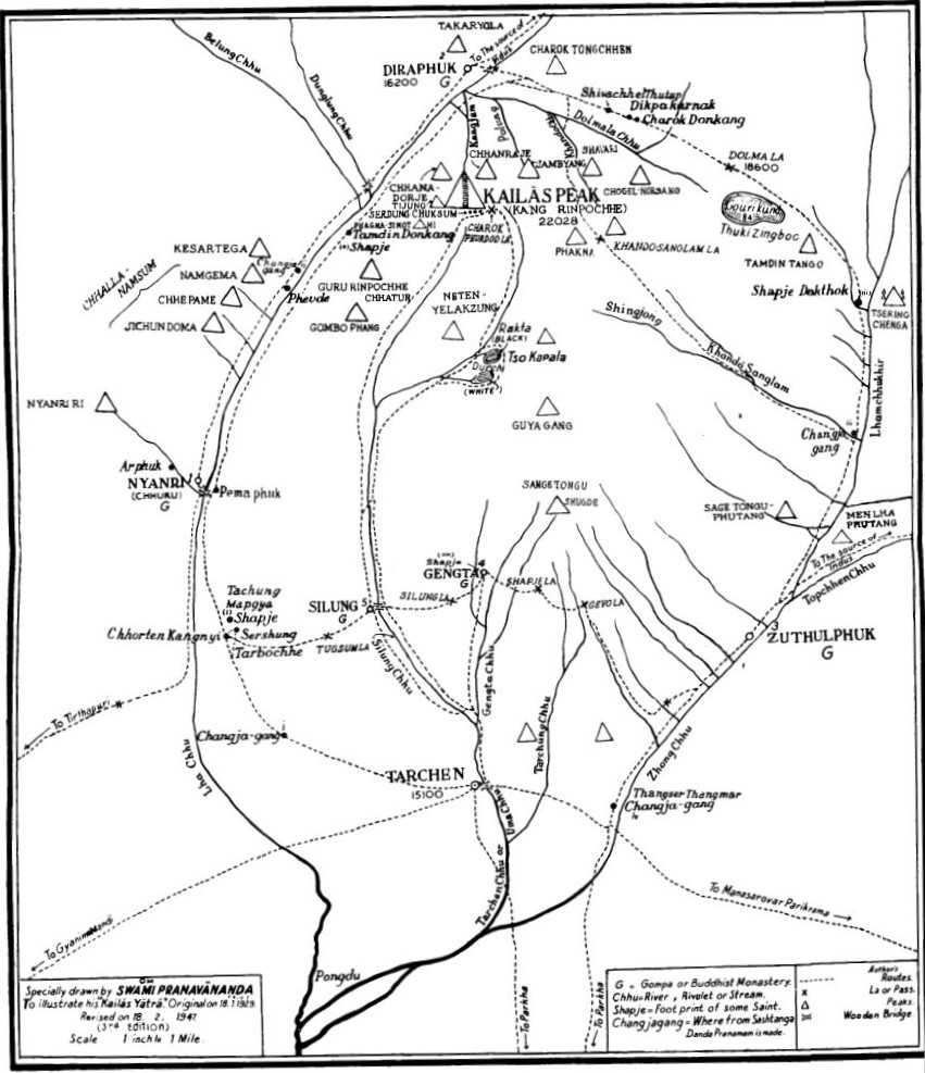
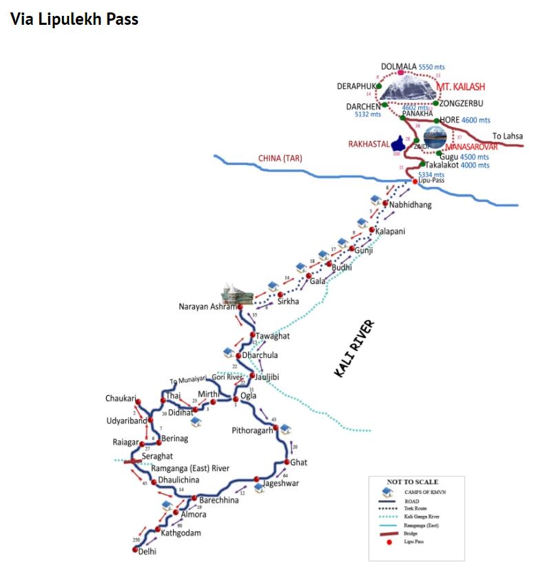
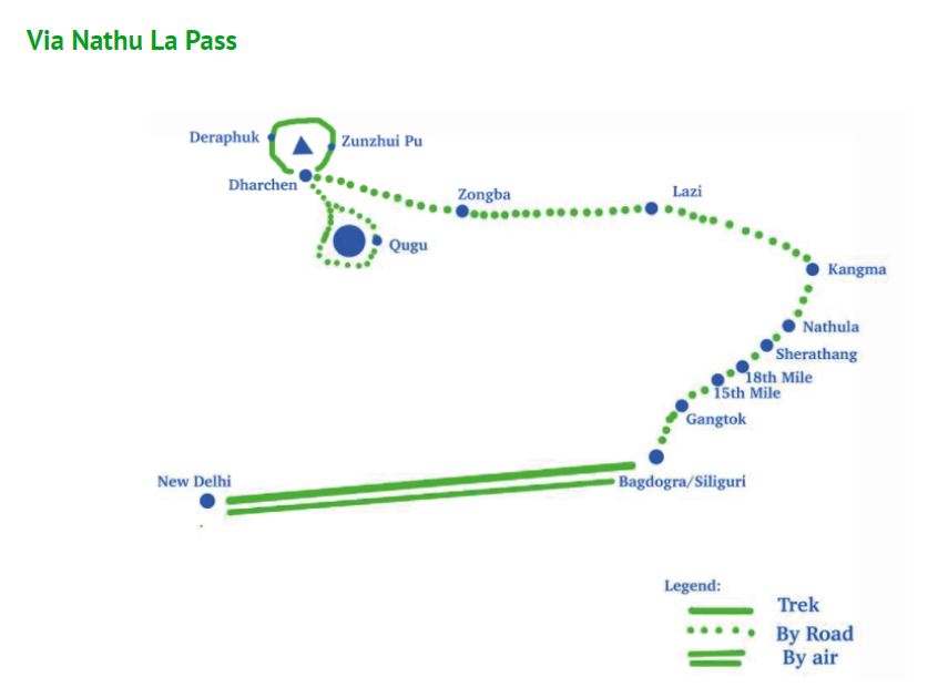
Mount Kailash
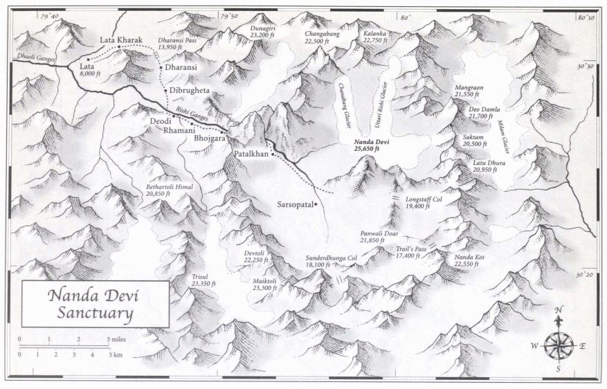
Nanda Devi
Altai-Himalaya A Travel Diary by Nicholas Roerich
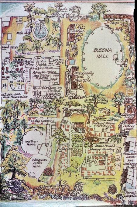
Rajneeshpuram
Rishikesh
Ashrams of India: Volume 2, Chapter 21 Uttarakhand.
A partial list of the 150-plus major and minor ashrams, temples, yoga centers and landmarks in Rishikesh from Hinduism Today (hinduismtoday.com).

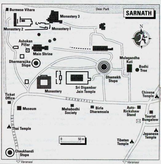
Sarnath
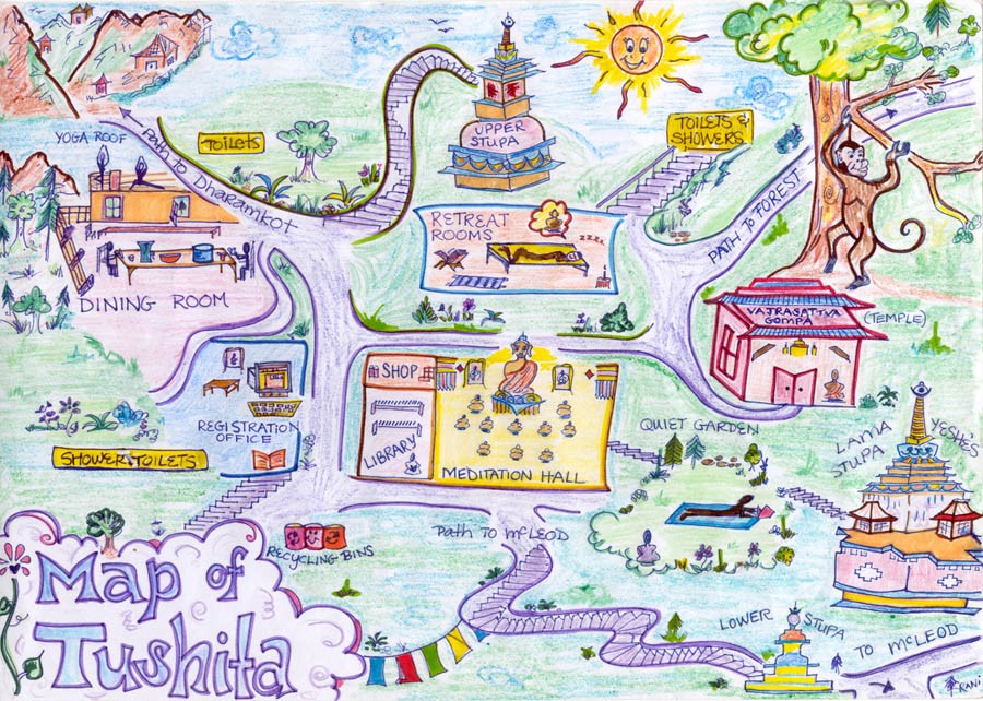
Tushita
Ashrams of India: Volume 1, Chapter 7 Himachal Pradesh. Map by Rani.
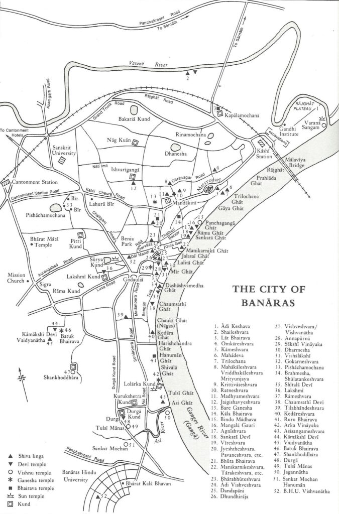
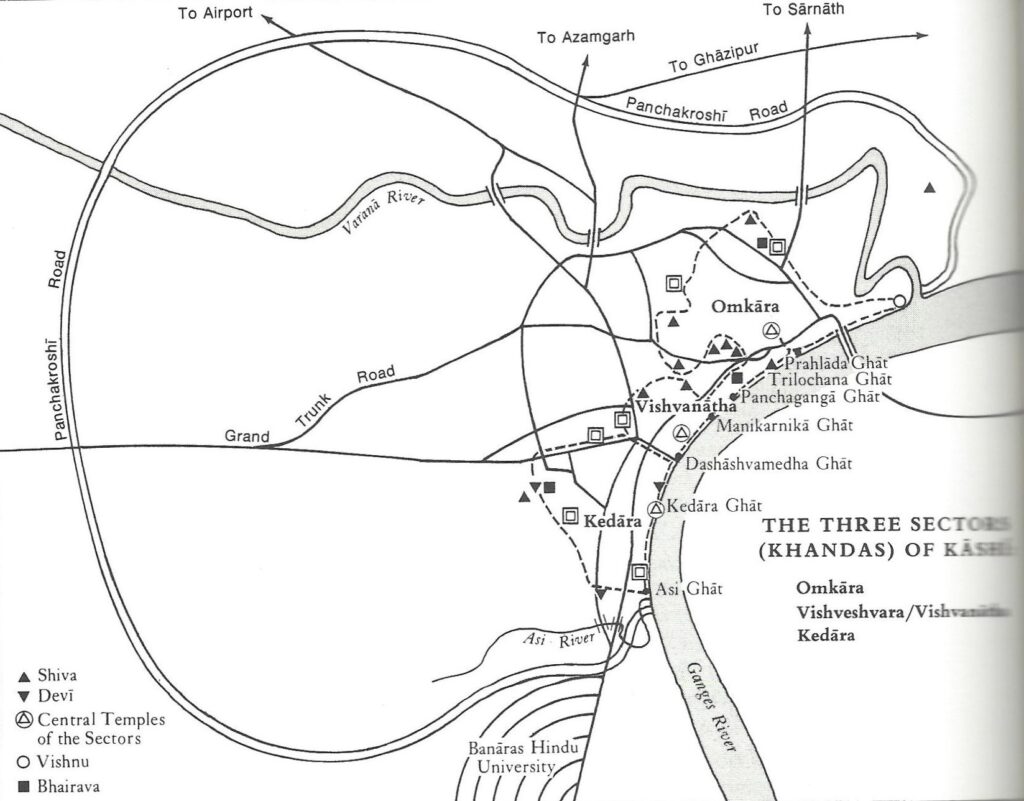
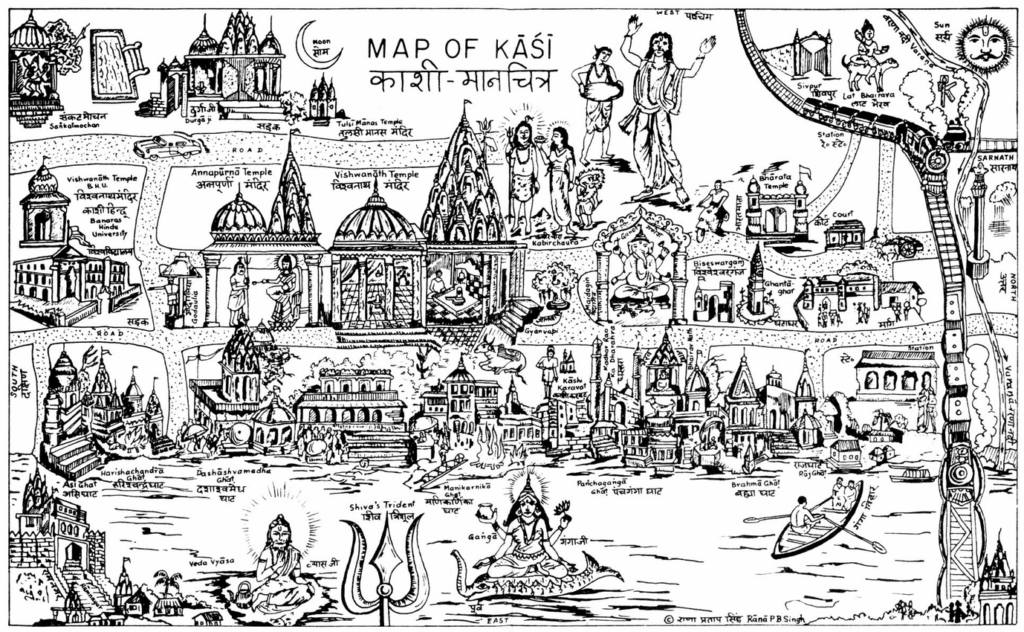
Varanasi
Ashrams of India: Volume 2, Chapter 22 Uttar Pradesh.
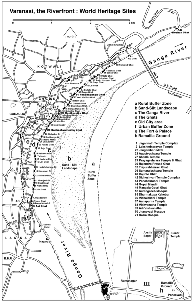
Among the total 84 ghats along the Ganga riverfront the 5 described as the most merit giving and sacred, called Pañchatirthis, are Asi, Dashashvamedha, Manikarnika, Panchaganga, and Adi Keshava. The importance of these five ghats has been first mentioned in the Matsya Purana, ca 6th century. Taking a sacred bath at these five ghats provides the same merit as bathing at all the ghats. These five ghats symbolise the ‘microcosmic body of Vishnu’, respectively as the head, chest, navel, thighs, and the feet. Thus the area along the ghat is eulogised as Vishnu’s body. The Ganga is the divine river who represents the integration of the trinity. She was born in the sacred pot of the Brahma (the Creator), got shelter in the toe of Vishnu (the Preserver) and roaming in the matted hair of Shiva (the Destroyer); and from Shiva one of the streams came on the earth. The 84 Ghats are narrated below,
(PDF Download of the Ghats in Varanasi in detail)
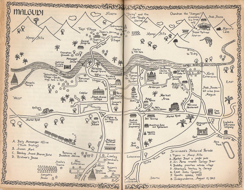
The fictional town of Malgudi
Malgudi is a fictional town located in South India in Ramanathapuram in the novels and short stories of R. K. Narayan. It forms the setting for most of Narayan’s works. Starting with his first novel, Swami and Friends (1935), all but one of his fifteen novels and most of his short stories take place here. Malgudi was a portmanteau of two Bangalore localities – Malleshwaram and Basavanagudi.